BLIGH ISLAND — Not far from an oily sheen on the waters of British Columbia's Nootka Sound is a site that the Mowachaht/Muchalaht First Nation considers the centre of the world.
Dorothy Hunt, who is part of the environmental unit for the Bligh Island Shipwreck response team, said it was a tense day when fuel leaking from a sunken cargo ship started drifting toward the historic village of Yuquot.
"Yuquot is the first village site for the Mowachaht/Muchalaht First Nation, so we've been really watching that on a daily basis to see if the current is taking the oil close to that site, because that would be devastating for the nation," said Hunt, who is also the lands and economic development manager for the First Nation.
"It was alarming to us because I don't believe there would be a way to boom off Yuquot. The ocean is wild out there," and prone to huge swells and waves, she said.
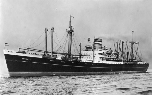
The MV Schiedyk left Gold River, B.C., with a load of wood pulp and barley on its way to Oregon on Jan. 3, 1968, and hours later hit a ledge off Bligh Island in Nootka Sound.
Nearly 53 year later, fuel from the ship is rising to the surface, prompting a co-ordinated response from multiple levels of government.
At the top of the decision-making structure is the unified command, comprising a Mowachaht/Muchalaht hereditary chief, and a representative each from the Canadian Coast Guard and B.C.'s Environment Ministry.
Hunt said she's been happy to see the First Nation's traditional knowledge of the area incorporated so quickly as part of the response. Much of it is based on a traditional land use database developed by the First Nation using everything from historical documents of explorers to interviews with elders.
"(The elders) would identify, well this is where we moved to in the winter months or this is our fishing camp in the summer months, so the database has a lot of our cultural information in it," Hunt said.
The database is typically consulted for things like logging proposals, but she said when fuel from the leak was seen, it was vital in identifying clam beds, seafood gathering sites and other places that are culturally significant and needed protection.
"Our traditional use information for the Mowachaht/Muchalaht is proving to be very useful in this whole task," she said, adding that booms were swiftly deployed to protect priority cultural sites.
Nootka Sound is an international destination for its beautiful waters, beaches, waterfalls and mountains. In the summer months, its channels are busy with tourists and fishermen alike, Hunt said.
Yuquot, which sits on the tip of a peninsula, is harder to protect. The name means "where the winds blow from many directions," and was the meeting point for 13 tribes to gather for summer harvests, according to the First Nation.
It's also where Captain Cook first met Chief Maquinna and it served as a centre for diplomatic relations with Britain and Spain.
But so far, Hunt said it hasn't been affected.
Jeff Bradey, who is part of the three-member unified command team as federal incident commander with the Canadian Coast Guard, said the coast guard and its partners do as much planning in advance of spills and other incidents to identify and protect important sites.
Western Canada Marine Response Corp. does mapping exercises all along the coast to identify areas that should be protected and develops local emergency contact lists in case of an incident, he said.
When a spill or incident happens, they turn to those emergency contacts, including local First Nations, for help identifying sites they may have missed.
"Each nation has its own method for passing that knowledge on to different generations," Bradey said.
So far, booms have been set up to protect everything from sensitive saltwater estuaries to clam beds, he said.
Ultimately, he said, the incident command's priority is getting the booms out for protection as quickly as possible.
— By Amy Smart in Vancouver.
This report by The Canadian Press was first published Dec. 20, 2020.
The Canadian Press


