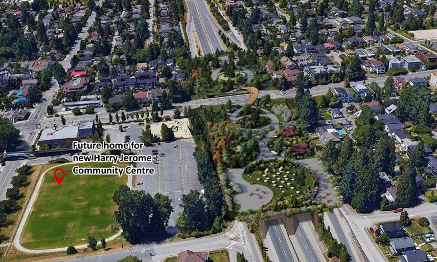
City of North Vancouver Mayor Linda Buchanan’s dream to cover over part of the Upper Levels Highway and build a new public park on top has edged closer to reality.
After pitching her ambitious plan to “bridge the sides of our city together” in an opinion piece in The Province back in March, Buchanan brought her bold idea forward as a motion at city council’s June 21 general meeting.
All but one councillor supported Buchanan’s motion for staff to conduct a feasibility study to see whether it’s possible and what the costs involved would be to build a land bridge across Highway 1, connecting both sides of the city.
Her vision is for a new public space that would bridge a community divided by the highway since the 1960s while increasing active transportation options and giving residents more access to green space, reducing highway noise and improving air quality.
In her plan, Highway 1 is “capped” for one block on either side of Lonsdale Avenue – a space of almost 400,000 square feet. The future park’s design and amenities would be decided through community consultation, but Buchanan envisions it having something for everyone.
She said her passion for the project was ignited during COVID-19, through reflections on how important the city’s role is in supporting residents’ health.
“This pandemic has been the catalyst for cities to really reimagine and look to how we can use our outdoor spaces in far better ways to support people,” she said, speaking at the meeting. “This new park would be a bold game changer in supporting people by creating connected healthy neighbourhoods,” Buchanan said. “A land bridge supports our vision and priorities, but it is also clearly aligned with the provincial and the federal governments’ objectives on health, the environment and the economy.”
Improving the safety of crossing the highway is also a huge priority for Buchanan, who remembers racing across it to get to school as a teenager.
“Despite several upgrades, Highway 1 remains a physical divide for our residents, and it is perceived to be extremely unsafe to cross by any active means,” she said. “This is a sentiment I hear often.”
While some doubt her plan, Buchanan said the idea has been floated before and she was inspired by a similar project that has proved to be a success in Tulsa, Okla.
“It is doable,” she said. “Places all over North America are doing it, they’re taking very wide highways, and they’re turning that space back into people places.”
With the city already planning to start consultations on a new east-west greenway along the Upper Levels and the Ministry of Transportation and Infrastructure currently engaged in the Upper Levels Interchange study, Couns. Jessica McIlroy and Angela Girard agreed with Buchanan that it was a good time to pitch the “bold idea.”
While Couns. Don Bell and Tina Hu voted for the feasibility study to go ahead, they did raise questions and concerns regarding the cost of the study and the project costs in general. Bell also questioned what the economic benefit would be from adding the park.
“I think there’s a lot of questions to be answered,” Bell said. “It is innovative, I’ll give you that.”
First applauding the mayor for her creative idea and its benefits, Coun. Holly Back voted against the study going ahead, noting that the city has “enough on its plate right now” with the COVID-19 restart, the Harry Jerome project and waterfront upgrades.
Staff will now move forward with a study on the feasibility of the project and a cost analysis.
While cost is at the top of the list for some on council, Buchanan is more focused on the benefits the new infrastructure would offer the community. “I would challenge all of us to think beyond initial capital costs and explore the social and economic value that progressive infrastructure could create,” she said. “Let’s explore it a little bit further and let’s look to the future to see what is actually possible.”
Elisia Seeber is the North Shore News’ Indigenous and civic affairs reporter. This reporting beat is made possible by the Local Journalism Initiative.


