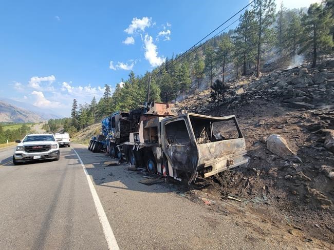
An evacuation alert has been rescinded for about two dozen properties near a stretch of Highway 3 in British Columbia's Interior, where a vehicle fire appeared to have spread to nearby grasses and started burning up a mountainside.
Karley Desrosiers with the BC Wildfire Service said the fire started around 1 a.m. Friday, and while the service was aware that a truck had caught fire along the highway south of Cawston, the connection between the vehicle and the wildfire hadn't been officially confirmed.
Helicopters were supporting 34 firefighters to get the blaze under control on the west side of Richter Mountain, she said, noting it was burning between the locations of two wildfires from previous seasons and slowing down as it reached rockier terrain.
There was no imminent threat or concern it would jump to the other side of the highway, Desrosiers said.
The wildfire had so far charred about 30 hectares, she said, or about a third of a square kilometre.
To the north, Desrosiers said the situation is "relatively stable" around the Keremeos Creek wildfire, near Penticton. The blaze had not grown beyond its 67-square-kilometre area.
The Regional District of Okanagan-Similkameen rescinded evacuation orders for properties around Keremeos and Olalla Thursday, downgrading them to alerts, but the Apex Mountain ski resort and surrounding homes remain on evacuation order.
More than 300 firefighters are assigned to the fire, with crews focusing their efforts on hot spots around the perimeter identified during an infrared scan, Desrosiers said.
The greatest activity has been along the northwest edge of the blaze, she said.
Heading into the weekend, Desrosiers said conditions are expected to be a bit drier, but also cooler. Temperatures are forecast to rise again on Tuesday.
Wind has been the primary driver of fire behaviour lately, she said, and is not expected to pick up strength again until later next week.
Severe thunderstorms have been rolling through the Interior, delivering hundreds of lightning strikes to areas already ranked at a high to extreme risk for wildfires.
Environment Canada thunderstorm watches remained in place Friday for much of the southeastern Interior, from the Similkameen region to the East Kootenays.
The wildfire service's website shows 69 new fires over the last two days, including one suspected lightning-caused blaze near Monte Lake, the same area where a massive wildfire destroyed homes last year.
The new fires remain small, but more lightning is in the forecast for southern and southeastern B.C.
Environment Canada said that at the height of Thursday's thunderstorms, Kamloops recorded a wind gust of 82 kilometres per hour. Gusts in Merritt reached nearly 60 kilometres per hour and the city was drenched by more than 23 millimetres of rain, causing some localized flooding.
Thunderstorms on Wednesday also brought heavy rain that caused mudslides along the Trans-Canada Highway between Spences Bridge and Lytton, which was ravaged by wildfire last year.
This report by The Canadian Press was first published Aug. 12, 2022.
The Canadian Press


